How complicated is a Belgian address? Not very complicated, until you dig deeper and discover the nightmare of inconsistencies.
We often think that to locate a building (in Belgium, but our neighbors experience a very similar situation) we need an address consisting of a street name (ending in Dutch with ‘…straat’, ‘…laan’, ‘…steenweg’, or beginning in French with ‘Rue…’, ‘Avenue…’, ‘Chaussée…’, or a similar prefix/suffix). Next comes a number, even on one side of the street, odd on the other. If we put a building between ’10’ and ’12’, it gets the number ’10A’, and if number 10 is a building with multiple apartments we distinguish them with ’10 bus 1′, ’10 bus 2′, etc. (or 10/1, 10/2, etc.). We must also include a municipality, along with the 4-digit postal code (5 in France). With this, the letter carrier should find your mailbox with ease.
While this is indeed true for most addresses, unfortunately the reality is often much more complicated. We have mentioned several times that databases can contain information that does not match reality, which can make geocoding difficult. In this article, we show that reality often contradicts common sense! And if a reality is not coherent, it clearly complicates its data management.
There are “Guidelines and recommendations for establishing and assigning an address (…)”(guideline – guide). The problem is that these are not always followed. Moreover, most streets and numbers were assigned before these guidelines were established.
Street names
In French-speaking Belgium, the 10 main prefixes (in order of occurrence) cover: Rue, Chemin, Avenue, Place, Clos, Route, Allée, Chaussée, Ruelle, Impasse) cover only 85% of the (62 000) street names. In the remaining 15%, we see some great classics (Drève: 0.4%, Boulevard: 0.3%, Square: 0.2%) but also numerous street names that we would find difficult to distinguish from a place name. Just over 2000 (3%) street names consist of a single word (such as “Dries” in Watermael-Boitsfort; not to be confused with the “Driesstraat” in Sint-Lambrechts-Woluwe); 1000 begin with a determiner (for example, “La Chapelle,” and not one of the 160 “Rue” or “Avenue de la Chapelle,” or “La Chavée” instead of one of the 35 variants of “Rue de la Chavée”). However, the latter cases are strongly discouraged by Article 8 §4 (“Street names without a road type are strongly discouraged”) of the above-mentioned directive.
On the Dutch-speaking side (Flanders and Dutch-language street names in Brussels), the situation is similar: the top 10 suffixes (straat, laan, weg, dreef, plein, steenweg, baan, hof, veld, berg) represent only 82% (88 000) of street names. We then see a large number of names with place names (Village, Garden District, Warande, etc.). We have 26 times “Vogelzang” in addition to 35 times “Vogelzangstraat” and other “avenue” or “dreef”.

One thing is certain: the 581 Belgian municipalities responsible for assigning street names have imagination in abundance! Not to mention the municipalities that have come up with the bright idea of giving intersecting streets particularly similar names: in Bièvre, the “Rue de la Violette” crosses the “Rue de la Volette”; in many Flemish municipalities, the “Boulevard de la Birch” crosses the “Boulevard de la Beek”; in Raeren, the Burgstrasse runs as an extension of the Bergstrasse. And if we look at streets that are close to each other but do not necessarily intersect, we have Ange/Angle (Charleroi), Carrière/Barrière (Serain), Ateliers/Bateliers (Châtelet), Beek/Beuk (Ternat), Hekel/Herel (Aalter), etc.
So write neatly on your envelopes – the letter carrier will thank you! It is no longer a surprise if the delivery man (or worse, the ambulance!) occasionally arrives in the wrong street….
However, the directive on address assignment calls for avoiding “streets with names that differ by only one letter” (8§5).
We even see a particularly interesting situation: in Charleroi, the right side of a street (Rue de Monseau) does not have the same name as the left side (Rue des chèvres)! Although a decision has been made to standardize, it will certainly take several months or years before the cartographic and official data are aligned.
House numbers
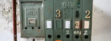
Unfortunately, there is no standard for numbering houses on a street. A distinction is often made between the number of the house (called the “house number” in the guideline, which usually refers to the entrance of the building) and the “bus number” (which refers to the floor, wing, block, etc.). If an address contains “5A,” it is not possible, unless you are on site or know the place, to know whether it is a house built next to 5 (in which case, number = 5A), or apartment A of number 5 (number = 5, bus = A). The same is true for 5/1. In other words, we do not know whether it is 5, 5A or 5/1 that designates the entrance to the building. There are many situations where a walled area is built instead of a house. How the new houses are numbered depends on the goodwill and imagination of the community: :
- At Clos du Manoir 13, in Limal, the new houses have the numbers 13/1, 13/2, …, 13/17. There is no bus number, the “/x” is an integral part of the number and not the bus.
- The number 1517 of the Waversesteenweg in Ouderghem chose letters: 1517A, 1517B…, to 1517P
- At Dieweg number 54, Uccle decided that the 20 or so new homes would have the same house number, but a bus number between 1 and 20.
Note that the distribution number/bus presented here is that of BeSt Address, which compiles the official information of the municipalities (although not free of quality problems, we will come back to that in a later article). However, it does not always correspond to the distribution indicated by geocoders such as OpenStreetMap, Here WeGo or Google Maps.
But the inconsistency doesn’t end there: next to number 10 you find 10 A, 10/2, as well as 10 bis. And if you merge 10 with its neighbor 12, the whole is often called 10/12 (or 10-12).
Thus, it is not possible in all cases to correctly split (or parse) an unstructured (or poorly structured) address into “number” and “bus” unless you know the correct format of each address.
In BeSt Address data, we can look at the format of house numbers by examining the “mask,” which consists of replacing each set of digits with a 0, and each letter with an A. The “0” mask (1, 12, 1977, …) covers 92.6% of addresses and “0A” (1A, 5B, 23C …) 7%. In Brussels and Flanders, there are 5 different masks. For Wallonia … 73! However, it is a safe bet that in many cases this is due to data quality problems.
The lack of uniformity in bus numbers is even worse: there are more than 400 different formats! Including 17 000 bus numbers consisting of one letter, difficult to distinguish from the above-mentioned house numbers in the “0A” format.
According to the directive (16§4), in theory, a number extension should be indicated by a capital letter immediately after the number (10A, not 10/2, 10a or 10 A) and a bus number should be numeric (19§6 and §7). But this is clearly not followed by the facts. We find that 99.6% of BeSt Address house numbers are compatible with these guidelines, but only 69.8% of bus numbers.
Apart from the naming aspect, the placement of numbers is not always consistent. Although even numbers are often on one side of the street and odd numbers on the other, they do not always both run in the same direction.

For example, rue François Michoel in Jalhay has only even numbers, with ascending numbers on one side and descending numbers on the other (see figure above, where the blue line follows the numbers in ascending order. Based on data from Best Address, using OpenStreetMap as a background map). This layout is also found in certain closed areas, such as the drève de Trévires in Wavre or the avenue Henri Wautier in Saintes.

We can also mention the Dennenhof at Tessenderlo, a street composed of several “sectors,” including one numbered 2, 4, 6, …, and another numbered 2A, 4A, 6A, 8A … 8A is therefore not between numbers 8 and 10, but between numbers 6A and 8A (idem for the Begijnenwinning in the same municipality).
The situation in homes with chalets or caravans is even more complex: in Tulderbos (Ravels), the numbers seem to have been drawn completely at random (see opposite) … poor letter carrier!
Zip code and municipality
As described in a previous article, at the time of writing, Belgium consists of 581 municipalities, each of which consists of one or more boroughs. Each borough has its own postal code, but it can be the same for each borough of the same municipality, different for each borough, or a mixture of the two. A zip code can thus be assigned to a municipality or to its boroughs.

However, the Brussels Capital Region has some anomalies. It consists of 19 municipalities, 18 of which have no boroughs and one (Brussels City) which has 4 (Brussels, Laeken, Haren and Neder-over-Hembeek). In practice, however, the municipality of Saint-Gilles is called both “1060 Saint-Gilles” and “1060 Brussels,” just like all other Brussels municipalities. In no other region of Belgium is a municipality referred to by its province or arrondissement. Elsewhere, a commune is referred to by combining its postal code with the name of the borough (1301 Bierges) or with the name of the municipality (1301 Wavre).
Moreover, during the 19th century, the municipality of Brussels City (or the City of Brussels) absorbed some areas of neighboring municipalities, which thus came under the authority of the City of Brussels, but whose postal code remained that of the original municipality. Thus, most of the area under the City of Brussels falls under postal codes 1000 (in blue on the map), 1020, 1120 and 1130 (the 4 boroughs), part under 1040 (European district, in green) and part under 1050 (Avenue Louise and Franklin Roosevelt Avenue, in gray). So Etterbeek does not own all of 1040 (only the brown part), and Ixelles does not manage all of 1050 (only the turquoise part, divided in two by Avenue Louise).
Conclusion
Smals Research spends a lot of time raising awareness of the complexity of keeping data relevant to the real world, both on this blog and in our projects and assignments. In this article, we illustrate that reality is sometimes fundamentally complicated by the fact that nomenclature (names of municipalities, streets, assignment of numbers) is left to the freedom of each municipality, with few restrictions. This leads to the inconsistencies described here. When you add in historical developments, it is easy to send the fire department to the wrong address!
This post is a submitted contribution by Vandy Berten, who specializes in data science at Smals Research. This article was written under his own name and in no way reflects the views of Smals.