Fathom Science has developed WhaleCast, a system that uses ocean predictions and machine learning to reduce the growing threat of ship collisions with the endangered North Atlantic right whale.
Fathom Science developed WhaleCast, a tool that uses ocean predictions to identify zones with a high risk of collisions between ships and whales. “No skipper wants to collide with a whale, but unfortunately whales are difficult to spot, especially in rough seas”, says Taylor Shropshire, oceanographer and co-founder of Fathom Science. “We are seeing more and more fatal collisions between ships and the North Atlantic right whale, which is also endangered.”
“Shipping traffic continues to grow and now accounts for 80 percent of world trade”, says Shropshire. By using machine learning and historical whale sightings, WhaleCast provides dynamic risk predictions that help shipping captains avoid these incidents.
Ocean Predictions
Daily weather forecasts support us in, for example, clothing choices, but have you ever heard of ocean forecasts? These predictions are not only important for shipping to estimate, for example, the waves or wind conditions in the ocean, but it can also save lives in the underwater world.
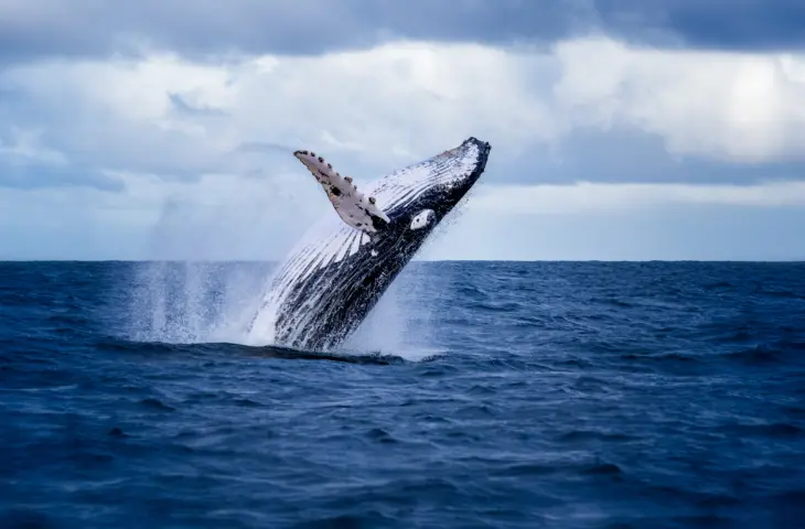
The North Atlantic right whale is endangered, with only 370 individuals remaining.
Taylor Shropshire, oceanograaf en mede-oprichter van Fathom Science
Fathom Science, a spin-off from North Carolina State University, develops software and data products for ocean forecasting. More specifically, they focus on maritime applications to improve the efficiency and safety of ports and shipping operations. “Recently, whale conservation has become an important topic in the maritime sector,” says Shropshire. “The continued increase in shipping traffic worldwide is accompanied by an increase in fatal collisions between ships and whales.” The North Atlantic right whale is of particular ecological importance due to its critically endangered status (International Union for Conservation of Nature (IUCN)), with approximately 370 individuals remaining in the population.
Continuously in Motion
“There are already websites and tools that indicate where the whales were spotted, for example, a few hours ago”, says Shropshire. “In certain situations this can be useful, but this information alone is not sufficient to avoid accidents.” He emphasizes that initiatives are already being taken by the American government, namely the National Oceanic and Atmospheric Administration (NOAA), such as the (seasonal) “slow zones”.
Yet this does not appear to be sufficient to avoid the many confrontations. “Whales are constantly on the move, which means there is a need for risk predictions about where and when the whales are expected to be”, says Shropshire. Fathom Science therefore developed a tool that makes risk predictions for the presence of whales in sea areas, called WhaleCast.
Reliability
“To create these risk predictions, we developed a machine learning model that predicts risks based on recent and historical observations,” says Shropshire. We worked with SAS, specializing in data and AI, to validate the reliability of these models.
The prediction model was validated with statistical and machine learning techniques via SAS’s Data for Good program. “For this, we used SAS Data Maker to generate synthetic datasets that closely resembled the original data, which provided a solid basis for training, validating, and testing seven different machine learning models with nearly 500,000 data points”, says Shropshire.
Whales in Sight
“Just as ships can consult ocean and weather forecasts from the ship on a display, we strive to make the risk predictions for whales also accessible on these displays. The predictions are cast in a dynamic heat map, which shows the probability of the presence of right whales”, says Shropshire. This allows skippers to better estimate where these right whales may be located, and consequently reduce their speed or change their route.

“We consciously choose to integrate the risk prediction map into the displays of ships, and not to develop yet another application that people need their mobile phone for”.
Privateers on the Coast
Getting the tool integrated into displays is one thing, but new challenges are also lurking around the corner afterwards. “We don’t want to create a tool that hinders other efforts, such as the government’s ‘slow zones’. In addition, we must prevent this data from being used for the wrong reasons, such as people abusing the whale locations to harass them”, says Shropshire. “Ultimately, the reality is that some vessels cannot deviate substantially from their route to avoid high-risk zones, but our technology can at least be used to increase awareness on the water.”
We are not interested in why right whales are in certain regions, but where and when they are somewhere.
Taylor Shropshire, oceanographer and co-founder of Fathom Science
Although there are no practical tools such as WhaleCast yet, the academic world has not been idle in recent years. “Many whale habitat and risk prediction models are strongly scientifically and academically focused, but not yet accessible to the average skipper”, he knows. They also want to be careful there and not step on the toes of the academic world. “Where scientific models want to answer the ‘why’ question, we are only trying to predict where the whales are with WhaleCast.”

The biggest challenge will arise when people effectively use the technology in practice. “If the tool indicates that there is a low risk, and ships therefore pass through at too high a speed, there is still a chance that whales are present. “It is important to monitor the correct and ethical use of the tool,” he says.
“At the moment we have only developed a tool for the right whales, but the same technology can be applied anywhere in the world to any species for which we have historical observation information.”